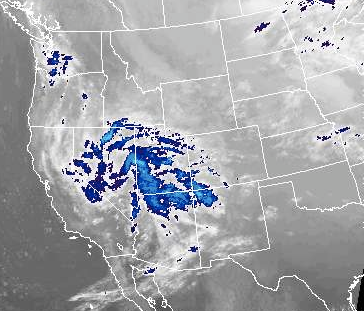
The messy winter storm that I told you about in my last post is still pegged to move into the SC KS area by Sunday Evening. The problem with this storm is that the most snow will fall under a band of moderate snow called a deformation band. The real guess work is, where will this band set up. Previous indications were showing that the band was going to set up along a Kingman north to Hutchinson line and extend east into Eastern Kansas. Now it looks as if this band could set up further north around the I-70 area.
This is the tricky part of winter weather forecasting, It is all so dependant on the track of the storm. Shifts north or south can drastically increase or decrease snow accumulation. I would say that it is a safe bet someone in SC KS will see 5+ inches of snow....but where?
Here is where the storm is at currently. It is gathering strength over the Rockies. It is still expected to drop south out of the Rockies and start heading through Central Texas.
No comments:
Post a Comment