Tired of this cold weather? I am too and it looks as if we might start to usher into spring next week. This cold trough of air appears to finally modify and move eastward and some nice warm air will be moving in from the South West.
With warm springtime temperatures come the chances for thunderstorms. It is to early to tell where exactly the best risk for Severe Weather will form at but so far, the best chances looks to be in the Arkansas/Texas area. I will keep you posted if severe weather looks to be on the way.
Also, I would like to remind you guys about the Storm Spotter training the National Weather Service of Wichita is giving out. You can find the full list of scheduled and upcoming talks Here.
Sunday, February 28, 2010
Monday, February 8, 2010
Its a snow day!!
El Dorado Public Schools are closed today. While we only got three inches of snow here 8 miles south of El Dorado, in El Dorado they had 5 inches. I remember going to bed and checking the radar one last time and thinking to myself, the heaviest band of snow is setting up right over El Dorado, and it did. I will have pictures of the beautiful snow here in a minute.
Sunday, February 7, 2010
Snow has Started
10:35 PM Update- Snow was coming down at good rate as some nice banding was going on over central Butler County. We probably have close to .75 inches of snow on the grassy surfaces. The main band is dropping what I would assume to be some impressive snow fall rates over Kingman, Wichita, and on through El Dorado. Snow Day??? Maybe in El Dorado where they are under the Heaviest band of snow.
Snowfall not really sticking to roads so that will definitely hurt our chances.
Edit 7:25 PM- The heavy band of snow has started to really get going over SC Kansas. Snow rates could be an inch an hour in some spots.
Snow started here at my house near Leon, Kansas at 4:50. It appears that the heavier band of snow which I highlighted in my previous blog might start to be setting up over SC KS. This would increase Snow accumulation across SC KS. 5 inches in that band is easily attainable. The NWS believes there could be 1" per hour rates periodically in the deformation band.
Right now the ground is too warm for snow to accumulate but that should change as the night goes on.
Enjoy the snow and, fingers crossed, a snow day!
Saturday, February 6, 2010
Quick Update on the Winter Storm
The messy winter storm that I told you about in my last post is still pegged to move into the SC KS area by Sunday Evening. The problem with this storm is that the most snow will fall under a band of moderate snow called a deformation band. The real guess work is, where will this band set up. Previous indications were showing that the band was going to set up along a Kingman north to Hutchinson line and extend east into Eastern Kansas. Now it looks as if this band could set up further north around the I-70 area.
This is the tricky part of winter weather forecasting, It is all so dependant on the track of the storm. Shifts north or south can drastically increase or decrease snow accumulation. I would say that it is a safe bet someone in SC KS will see 5+ inches of snow....but where?
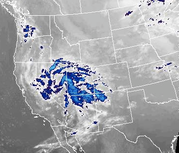
Here is where the storm is at currently. It is gathering strength over the Rockies. It is still expected to drop south out of the Rockies and start heading through Central Texas.
This is the tricky part of winter weather forecasting, It is all so dependant on the track of the storm. Shifts north or south can drastically increase or decrease snow accumulation. I would say that it is a safe bet someone in SC KS will see 5+ inches of snow....but where?
Here is where the storm is at currently. It is gathering strength over the Rockies. It is still expected to drop south out of the Rockies and start heading through Central Texas.
Friday, February 5, 2010
Winter Storm February 7-10

A cold arctic air mass is going to spill southward (image above) out of Canada on Saturday night. The colder air should arrive in Kansas around mid-day Sunday. Temperatures will be around 10 degrees below average when this cold polar air moves in.
On to part two, which is the storm itself. A Low Pressure system is set to drop out of the Rockies on Sunday. This storm is progged travel through central Texas gathering moisture from the Gulf of Mexico as it moves eastward. Snow will fall on the Northern side of the storm while rain and a few thunderstorms will fall on the South side of the storm. As the storm moves out of SC KS it moves NNE and becomes really elongated (stretched out) from Texas to Michigan. It could end up being another big snowmaker for the DC area that is getting POUNDED by a Nor'Easter Right now.
Now on to what you all are wondering, how much snow can SC KS expect from this system? While it is only three days away there is still some uncertainty as to where this LP will track and to how much the dry arctic air will affect accumulations. I would say there could be a solid swath of 6+ inches through South Central Kansas.
Here is a broad map of the storm:

Subscribe to:
Posts (Atom)